


The Hurricane Questions
None of them are about windspeed
[Editor’s note: Yes, I am working on a new politics & current events newsletter that you should see/receive very soon. Wanted to post this for all you hurricane watchers and also test out the email system for this substack thing. Thank you for your patience.]
Good morning, veteran hurricane reporter here.
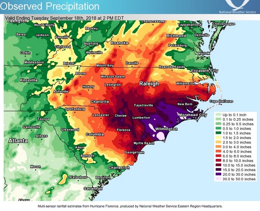
Of course you shouldn’t lose track of how powerful a storm is. That said, please don’t concentrate on categories and windspeed. North Carolina has been devastated by repeat disasters, major storms, but almost none of that was from wind damage. The above image is the rainfall map for Hurricane Florence, the most damaging storm by far in our state’s history. Hurricane Florence hit North Carolina as a Category 1. As it approached, the language used by forecasters, repeated dutifully by people in my business, was that the storm was “weakening.” I still find that unforgivable. If I could do one thing to change the way people tend to think about hurricanes and tropical storms it would be to change the focus from wind to water.
The power of storms is important as they pass through eastern North Carolina because storms drive water in North Carolina’s extensive network of sounds and rivers. This is especially true for storms that pass close enough to Pamlico Sound, which is very large (2nd largest lagoon on the East Coast) and very shallow. A scientist once explained it to me as the difference between how water behaves in a deep bowl compared a baking pan. When it gets disturbed, the water in the baking pan sloshes around a lot more. As a hurricane passes through Pamlico Sound it shoves the water back and forth. During major storms that pass off the coast, for instance, it is not uncommon for the sound to go dry up near Nags Head, as it did during Hurricane Dorian, when the storm drove the waters of the sound toward Ocracoke.
1. Where is this thing going?
So, first thing to ask and unfortunately, the last thing to usually get nailed down is the track. That’s really important because of the above mentioned reason. In North Carolina there are thousands of miles of coastline, soundside and riverside areas exposed to the immediate threat of storm surge. Because of the sounds, the final track as a storm passes is very important because it will push water toward different areas depending on whether the center of the storm is east or west of the body of water as it passes.
2. When is is going to get here?
I usually have a screen of tide tables open when I’m looking at track predictions. Tides affect a lot more areas than just the coastline and sounds. For instance, there’s still a noticeable tidal effect on the Neuse upriver from Kinston.
A storm surge on top of a high tide can do a lot of damage and unless a storm is traveling fast it is likely that during its course there will be places in North Carolina that get the combination.
3. How fast is it moving?
Very wet, slow moving storms are by far the most dangerous and have brought the most misery to North Carolina and elsewhere. This is the stat that always scares me the most.
4. How wet is the storm?
I didn’t want to prioritize these questions too much because it’s hard to tell which is more important between how wet a storm is and how fast it’s moving. This is one of those questions that’s not easy to eyeball from a map or a chart. You’ll need a scientist to tell you the answer to this one. The term for it is precipitable water.
5. How large is the storm?
This is important for a couple of reasons, none of which have to do with the potential for wind damage west of I-95. How far from the center the rain bands and tropical storm force winds extend tells you a lot about the potential for storm surge/riverine flooding mentioned above, as well as how much rain will fall in the various watersheds, which determines the extent and location of flooding after the storm passes.
6. How much rain in the past month or so?
How saturated the soils are can have a big effect during the storm because more trees come down. In the mountains, a storm on top of already saturated soil can trigger landslides on unstable slopes. After the storm, the capacity of the land to absorb water is a critical factor in determining the potential for flooding.
If I can think of anything else, I’ll add this to the list. — kmr
BTW I did see the sub heading, but if you remember Fran, it was about wind speed and tornadic/supercell activity it spawned
7) wind speed warnings and history?
Under storm surge you might mention inundation, peak surge and flash flooding.
States of emergency, shelters opening, national guard activation, disaster declarations all come to mind.
By the time it gets to us, ISAiAS is projected to be a tropical storm rather than a hurricane.